Malaysia Launches New Project to Map Sabah
Source: ASM Magazine
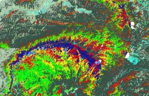
Thursday 21 Aug 2008: Malaysia has launched Digital Sabah, a project that aims to take the mapping of Sabah, on Borneo, to a new level. It will involve a synthetic aperture radar view of the topography. It is the first time that the Malaysian government has allowed aerial data to be acquired and then distributed to a large number of parties.
Officials from both government and private companies signed an agreement at the Map Asia conference last week to launch Digital Sabah, a project to map the Malaysian province of Sabah, on Borneo.
Sabah has been mapped before. However, the Digital Sabah project aims to take the represention of Sabah to a new level. It involves a synthetic aperture radar view of the topography, which will lead to a digital surface model, a digital terrain model and other products derived from them.
The SAR was operated by Intermap Technologies, a Canadian aerial surveyor, which flew over the island in December 2007 and January 2008. Antaragrafik and Credent Technology are processing the data, and will distribute products to end users.
Credent's Bill Love said the project would show Sabah in unprecedented detail.
He said the first aim of the processing would be to generate a digital surface model of the state. A digital terrain model or bald Earth view would follow.
Sabah is mostly dense forest, so the different between these two is largely the biomass, a data set aimed squarely at forestry companies.
He said there are also a number of other commercial ventures, both in government and the commercial space, which would be interested in the data.
The project is special because it is the first time the Malaysian government has allowed aerial data to be acquired and then distributed to a large number of parties. Normal practice is that data is acquired for a single client, and only for that client.
In this instance, the data will be stored online and, provided clients can satisfy government they have a legitimate reason for acquiring it, the data can be acquired on a commercial basis.
Part of the deal is that this permission will not be unreasonably withheld. While foreign military interest would probably not be welcome, interest from exploration, forestry or utility companies, not to mention other government agencies, will be embraced.